One of the initial steps in establishing a data set for studying neighborhood effects on health and/or behaviors is to decide on how the concept of “neighborhood” is going to be operationalized. Depending on the available data there are several ways in which the neighborhood of interest can be defined. The neighborhood definition chosen for use in a research project is usually the result of a compromise between data availability, the conceptual relevance for the outcome being studied and confidentiality concerns. The figure at the bottom of this page depicts many of the available strategies.
Neighborhood Definitions
- Census Tracts – the area encompassed by a subject’s residential Census Tract is used as the definition of neighborhood.
- Zip code – the area encompassed by a subject’s residential Census Tract is used as the definition of neighborhood.
- Census Tracts or Zip codes with buffers – because these administrative geographies often have arbitrary boundaries, a subject’s neighborhood might be defined as the Tract plus a 400 yard buffer around the tract.
- Radial Buffer – all space within a fixed radius of the subject’s address, common radial distances include 0.25 Km, 0.5 Km, 1/2 mile and 1 Km. This definition requires an exact address.
- Street Network Buffer – all space that can be reached within a fixed distance travel along the street network from the subject’s address, common radial distances include 0.25 Km, 0.5 Km, 1/2 mile and 1 Km. This definition requires an exact address.
- Activity Space – the area between two addresses, such as home and Head Start or Home and School. A buffer is placed around each address and the buffers are projected onto each other, such that all space within the two buffers and the projection is defined as the neighborhood. This definition requires an exact address.
- Minimally Convex Hull – a polygon area encompassing geocoded points bounded by line segments such that all internal angles equal 180 degrees or less. This approach is useful for GPS monitoring data.
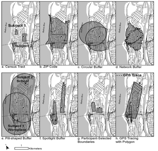
Image by Daniel Sheehan, originally published in Public Health Reviews Vol. 33, No.2, 484-506, 2011.

