Our work on pedestrian safety is an extension of our work on how urban design can be used to support engagement in pedestrian activity and physical activity. As we have built our portfolio of pedestrian injury research, we have come to realize that alcohol use by the injured individual is a common thread for injuries to pedestrians caused by falls and motor vehicles and for injuries to users of micromobility devices (e.g. bicycles, e-bikes, scooters). In 40% of instances where a pedestrian was killed by a motor vehicle, the pedestrian was under the influence of alcohol when struck. Among pedestrians experiencing an injurious fall, where syncope and heat illness were not contributing factors, substance use prevalence was 30.3% in the age group 21 to 64 years; alcohol use alone for 26.3%, drugs alone for 2.6%, and alcohol and drugs for 1.4%.
The high prevalence of alcohol use among injured pedestrians is a concern because many cities, as part of economic development plans to revitalize urban centers, are now developing and promoting nightlife and nightlife districts, prominently featuring alcohol-serving establishments. Nightlife districts encourage patrons to walk between nearby alcohol serving venues. Furthermore, multiple jurisdictions have open container laws, that allow drinking on streets and sidewalks, and to-go alcohol purchases, policies that also encourage walking and drinking. As cities focus on re-building the nighttime economy after the pandemic, the number of pedestrians under the influence of alcohol is likely to increase. Urban design to protect nightlife patrons from injuries should be incorporated into the development of the nightlife economy.

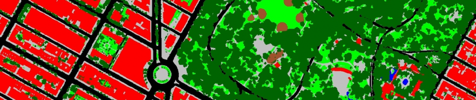
We were the first to use Google Street View to collect data on pedestrian infrastructure and conduct a location-based analysis of risk factors for pedestrian injuries from automobiles using these streetscape-level data. We have since published the audit tool, demonstrated its reliability and have published the methods for implementing the tool using Google Street View. We are currently funded by NIAAA to conduct a nation-wide location-based case control study of risk factors for pedestrian fatalities.
- Use of Google Street View to Assess Environmental Contributions to Pedestrian Injury
- Pediatric emergency department visits for pedestrian and bicyclist injuries in the US
- Development and Validation of a Google Street View Pedestrian Safety Audit Tool
We have also developed a protocol to use NEMSIS standardized EMS data to identify cases of pedestrian falls, syncope and heat illness occurring on streets and sidewalks. Our analyses of NEMSIS data show that the burden of severe injuries from pedestrian falls is larger than that from pedestrians being hit by motor vehicles.
- A methodology for the public health surveillance and epidemiologic analysis of outdoor falls that require an emergency medical services response
- A National Study on the Comparative Burden of Pedestrian Injuries from Falls Relative to Pedestrian Injuries from Motor Vehicle Collisions
- Clinical trauma severity of indoor and outdoor injurious falls requiring emergency medical service response
- Prevalence of indications of alcohol and drug use among patients treated for injurious falls by Emergency Medical Services
We have recently expanded our work on injury prevention to includes studies of injuries associated with micromobility devices (bicycles, e-bikes, scooters and e-scooters).
- The Burden of Injuries Associated With E-Bikes, Powered Scooters, Hoverboards, and Bicycles in the United States: 2019‒2022
- Use of Generative AI to Identify Helmet Status Among Patients With Micromobility-Related Injuries From Unstructured Clinical Notes
- Comparing alcohol involvement among injured pedalcycle and motorcycle riders across three national public-use datasets
We have also done substantial work on improving causal inference in injury epidemiology research, including defining epidemiologic approaches to conceptualizing and addressing the “unknow denominator” problem in automobile and pedestrian injury research; on study designs using injury registry data such as FARS and NEMSIS; and on case-control and case-only analyses of interactions and etiological heterogeneity using injury registry data. We have also conceptualized and developed the location-based case-control design which is useful for studying injury events where the exposure of interest is the surrounding immediate environment.
- Registry Data in Injury Research: Study Designs and Interpretation
- Causal Inference with Case-Only Studies in Injury Epidemiology Research
- The unknown denominator problem in population studies of disease frequency
- Design of a Location-Based Case-Control Study of Built Environment Risk Factors for Pedestrian Fatalities in the U.S.

